


AR TSUNAMI CAMERA FIELD MUSEUM app for iPhone and iPad
Developer: Nabla-Zero Co., Ltd
First release : 30 Apr 2012
App size: 148.43 Kb
AR TSUNAMI-CAMERA FIELD MUSEUM is a tool to recreate the depth of tsunami caused by the Great Eastern Japan Earthquake at the site in the damaged areas. The longitude and latitude where you are standing are measured by GPS, then these values are sent to the server through the internet. Your smart phone receives the estimation of the depth of tsunami and then you can see "the true depth of tsunami at the place where you are". Please note that this application presents a function of "field museum" then it can only be used in the areas where tsunami damages actually happened.
You can check "where you can use this app" from http://nabla-zero.jp/iphone/museum_map.html
The data of the tsunami height have been made by some institutes and authorities. This application depends on the "Map of the Tsunami Inundation" prepared by the Geospatial Information Authority of Japan, etc. However, these estimations will contain some differences then you can feedback the "true height of the site" to our data server. In this way, "the more peoples participation" will make "the more precise memory".
How to use:
How you can use it is demonstrated at the following URL; http://www.youtube.com/watch?v=1Jak2EchHZk
1. Turn on GPS and it checks the current position. Positional data send to the server and then the app receives the tsunami inundation data where you are standing. It takes about 10 seconds but more than 1 minute, in some occasions.
2. When the apps screen changes, the left side of the dial shows the height of tsunami having received from our data server. If you wish to change it, turn and set the height value. Set your own height by the mid dial. Distance to the object you want to show the tsunami is set by the right dial. The distance should be measured as precisely as possible by a measurement tape.
3. Push OK button.
4. Hold your smart phone in an upright position at your eye height then tap the first cross with the target on the wall. Tap the second cross appeared 1/8 above the bottom of the screen with the same target on the wall. While you are tapping these two crosses, never change the holding height of your smart phone, only to change the angle of it.
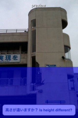
5. The actual tsunami height caused by the earthquake will be projected in blue on the wall. Do not change the holding position of your smart phone, only to change the angle and viewing direction while you see the "tsunami".
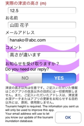
6. If the height of tsunami you see in the screen is largely different from your own experience or actual height, please send your reports to us from the next screen. Please write down your email address if you need our reply.
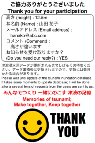
Note: We use personal information only to improve this application, never to use other purposes. We will let you know update of the tsunami inundation database, if you give your email address to us.